|
Tim Dawson
|
|
|
Group: Forum Members
Posts: 8.2K,
Visits: 9.7K
|
I asked you to name some Swiss airfields where this would be highly useful and you didn't name a single one.
|
|
|
|
|
cocoroman
|
|
|
Group: Forum Members
Posts: 70,
Visits: 116
|
+xI asked you to name some Swiss airfields where this would be highly useful and you didn't name a single one. Sorry Tim, I surely didn't get your question. We can start with:LSGL,LSGC,LSGS,LSZB,LSZG,LSGG,LSZF,LSZA,LSGY,LFSB and Obviously LSZH etc. those are the most important VFR+IFR airfields in Switzerland. Thanks for your attention. Cheers,
|
|
|
|
|
Tim Dawson
|
|
|
Group: Forum Members
Posts: 8.2K,
Visits: 9.7K
|
We will georeference Swiss airfield diagrams over the next 24 hours and you will then be able to taxi around on them in SkyDemon as much as you like.
|
|
|
|
|
cocoroman
|
|
|
Group: Forum Members
Posts: 70,
Visits: 116
|
Thanks a lot Tim, for us Swiss Pilots would be the Summer Gift :-))
Cheers,
|
|
|
|
|
cocoroman
|
|
|
Group: Forum Members
Posts: 70,
Visits: 116
|
Hi Tim, really thanks a lot in name of all Swiss Pilots, I think we should really profit of this in the future.
Now the question; do we have to do a proceed some thing special to have this action? E.g.uninstall and install again, or re download the charts or something else. Because, I don't see any change on my SD. Which concerns geo-referenced Taxing and so on. I have checked and re checked agin tonight. But there is nothing happening at the moment, it is like before. Or we didn't understood right what the asking was.. Take care..
|
|
|
|
|
Tim Dawson
|
|
|
Group: Forum Members
Posts: 8.2K,
Visits: 9.7K
|
You should see the standard georeferenced button next to many airfields in Switzerland now. If the chart has been downloaded, it'll pop up automatically when you land.
|
|
|
|
|
cocoroman
|
|
|
Group: Forum Members
Posts: 70,
Visits: 116
|
+xYou should see the standard georeferenced button next to many airfields in Switzerland now. If the chart has been downloaded, it'll pop up automatically when you land. I don't see any geo-referaenced button next to Airfields. Only things happening, when I land and stop, sometimes it will turns into a Plate of this Aerodrome. I have re downloaded Swiss charts again. Still no go, maybe you can tell me which should I have download and where to get it. BTW, I'm no more on Android, it is iPad at the moment. Maybe you are talking about Android? or I don't know anymore..
|
|
|
|
|
Sky Painter
|
|
|
Group: Forum Members
Posts: 627,
Visits: 15K
|
+x+xYou should see the standard georeferenced button next to many airfields in Switzerland now. If the chart has been downloaded, it'll pop up automatically when you land. I don't see any geo-referaenced button next to Airfields. Only things happening, when I land and stop, sometimes it will turns into a Plate of this Aerodrome. I have re downloaded Swiss charts again. Still no go, maybe you can tell me which should I have download and where to get it. BTW, I'm no more on Android, it is iPad at the moment. Maybe you are talking about Android? or I don't know anymore.. It may help if you read Page 44 of the SD Manual.
Mike _________________________________________ Samsung Galaxy Tab A8 – Android 11.0 & SD 4.2.2 Huawei P30 – Android 11.0 & SD 4.2.2
PC – Windows 10 (Home Ed) Version 22H2, Build 19045.6575, SD 4.2.2
|
|
|
|
|
cocoroman
|
|
|
Group: Forum Members
Posts: 70,
Visits: 116
|
+x+x+x+x+xYou should see the standard georeferenced button next to many airfields in Switzerland now. If the chart has been downloaded, it'll pop up automatically when you land. I don't see any geo-referaenced button next to Airfields. Only things happening, when I land and stop, sometimes it will turns into a Plate of this Aerodrome. I have re downloaded Swiss charts again. Still no go, maybe you can tell me which should I have download and where to get it. BTW, I'm no more on Android, it is iPad at the moment. Maybe you are talking about Android? or I don't know anymore.. It may help if you read Page 44 of the SD Manual. I don't see any geo-referaenced button next to Airfields. Only things happening, when I land and stop, sometimes it will turns into a Plate of this Aerodrome. I have re downloaded Swiss charts again. Still no go, maybe you can tell me which should I have download and where to get it. BTW, I'm no more on Android, it is iPad at the moment. Maybe you are talking about Android? or I don't know anymore.. It may help if you read Page 44 of the SD Manual. Sky Painter, this is second time you are answering me, both were wrong.. Maybe you should read carefully my thread before answering. I'm talking about Taxi Ways. With theire in and out names (C,B,A etc. and "C" Office, real Airfield Ground and Taxi fascility. But not about Plates, Capiche..
|
|
|
|
|
cocoroman
|
|
|
Group: Forum Members
Posts: 70,
Visits: 116
|
+x+x+x+x+x+xYou should see the standard georeferenced button next to many airfields in Switzerland now. If the chart has been downloaded, it'll pop up automatically when you land. I don't see any geo-referaenced button next to Airfields. Only things happening, when I land and stop, sometimes it will turns into a Plate of this Aerodrome. I have re downloaded Swiss charts again. Still no go, maybe you can tell me which should I have download and where to get it. BTW, I'm no more on Android, it is iPad at the moment. Maybe you are talking about Android? or I don't know anymore.. It may help if you read Page 44 of the SD Manual. I don't see any geo-referaenced button next to Airfields. Only things happening, when I land and stop, sometimes it will turns into a Plate of this Aerodrome. I have re downloaded Swiss charts again. Still no go, maybe you can tell me which should I have download and where to get it. BTW, I'm no more on Android, it is iPad at the moment. Maybe you are talking about Android? or I don't know anymore.. It may help if you read Page 44 of the SD Manual. Sky Painter, this is second time you are answering me, both were wrong.. Maybe you should read carefully my thread before answering. I'm talking about Taxi Ways. With theire in and out names (C,B,A etc. and "C" Office, real Airfield Ground and Taxi fascility. But not about Plates, Capiche.. 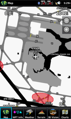 Like this one for example ..
|
|
|
|